
If you’ve ever tried to navigate a city only to find a road unexpectedly closed, or managed a logistics team rerouting trucks because of a surprise construction site, you know how quickly inaccurate MAP data can throw a wrench into your day. In fact, . And it’s not just about inconvenience—these errors can lead to missed deliveries, compliance headaches, and even public safety risks. That’s why MAP violation software is quickly becoming a must-have for cities, logistics teams, and any business that relies on geospatial data to keep things running smoothly.
So, what exactly is MAP violation software, and why is it suddenly in the spotlight? Let’s break down what it does, how it’s transforming industries from urban planning to logistics, and how tools like are making it easier than ever to keep your map data accurate, compliant, and actionable.
MAP Violation Software: What Is It and Why Does It Matter?
At its core, MAP violation software is a specialized tool designed to detect, flag, and help manage violations or inconsistencies in map data. Think of it as the digital watchdog for your geospatial information—constantly scanning for unauthorized changes, inaccurate coordinates, illegal constructions, or any other discrepancies that could impact operations or compliance.
Here’s what MAP violation software typically targets:
- Unauthorized changes: Unapproved road modifications, new buildings, or changes to public infrastructure that aren’t reflected in official records.
- Inaccurate geospatial data: Errors in addresses, coordinates, or boundaries that can disrupt deliveries, emergency response, or urban planning.
- Illegal constructions: Buildings, signage, or structures erected without proper permits, often detected via satellite imagery or MAP overlays.
Why does this matter? Because accurate MAP data is the backbone of everything from city management to last-mile delivery. When your MAPs are out of date or riddled with errors, you risk inefficiency, regulatory fines, and a whole lot of frustrated customers or citizens. In fact, .
Key Functions of MAP Violation Software
So, what does MAP violation software actually do? Here are the core features you’ll find in most modern solutions:
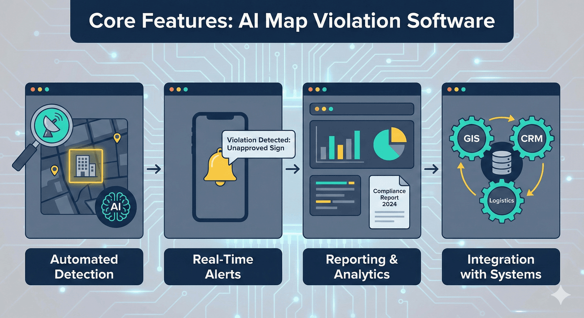
- Automated Detection: Uses AI, satellite imagery, and data scraping to scan for MAP violations—no more manual checks or field visits for every update.
- Real-Time Alerts: Notifies teams instantly when a violation is detected, so you can act before small issues become big problems.
- Reporting and Analytics: Generates detailed reports on violations, trends, and compliance status, making it easy to track progress and justify decisions.
- Integration with Existing Systems: Connects with GIS, CRM, or logistics platforms to ensure MAP data stays consistent across your organization.
For example, a city planner might get an alert when a new building appears in satellite imagery but isn’t in the city’s permit database. Or a logistics manager could receive a report highlighting roads that have changed since the last delivery route was planned.
These features don’t just make compliance easier—they actually streamline operations, reduce manual labor, and help teams focus on higher-value tasks. As , moving away from pen-and-paper inspections to automated, MAP-based compliance tools can transform how organizations manage risk and regulatory requirements.
MAP Violation Software in Action: Urban Management and City Planning
City governments and urban planners are some of the biggest beneficiaries of MAP violation software. Why? Because cities are constantly changing—new buildings go up, roads are rerouted, and signage appears (sometimes legally, sometimes not). Keeping up with these changes manually is a losing battle.
With MAP violation software, cities can:
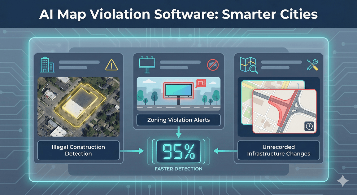
- Identify unauthorized buildings or illegal constructions using satellite imagery and AI-powered object detection ().
- Spot unapproved signage or billboards that violate zoning laws.
- Detect road changes or infrastructure modifications that haven’t been officially recorded.
For example, highlights how illegal construction is a growing problem in many cities, leading to safety risks and lost tax revenue. By automating detection, cities can enforce regulations faster and more fairly—sometimes catching violations within days instead of months.
The impact? Faster enforcement, improved public safety, and smarter urban planning. And let’s be honest—less time spent chasing down paperwork or field reports means more time for actual city improvements.
Thunderbit and MAP Violation Software: Supercharging Data Collection
Now, here’s where things get really interesting (and where my team at Thunderbit comes in). One of the biggest challenges with MAP violation software is feeding it accurate, up-to-date data from a variety of sources—think Google Maps, OpenStreetMap, city databases, and even street-level imagery.
is an built to make this process painless. Here’s how Thunderbit can boost your MAP violation workflow:
- Scrape data from multiple MAP platforms: Whether you need business listings, road changes, or new construction data, Thunderbit can extract it from Google Maps, city GIS portals, and more.
- AI-powered structuring: Just click “AI Suggest Fields,” and Thunderbit will automatically structure the scraped data—addresses, coordinates, images, and even contact info—so it’s ready for your MAP violation software.
- Bulk and scheduled scraping: Need to monitor hundreds of locations or update your data daily? Thunderbit can automate the process, saving hours of manual work.
- Subpage and pagination scraping: For complex MAP platforms with multiple layers or pages, Thunderbit’s subpage scraping ensures you don’t miss a thing.
This means your MAP violation software is always working with the freshest, most comprehensive data possible—no more outdated MAPs or missed violations. And for teams that need to scale up quickly, Thunderbit’s can process 50+ pages at a time, all while keeping your workflow simple and intuitive.
How MAP Violation Software Outperforms Traditional MAP Data Review
Let’s be real: before tools like MAP violation software, most organizations relied on manual reviews, field inspections, or legacy GIS systems to catch MAP errors. It was slow, expensive, and prone to human error. Here’s how the new approach stacks up:
| Feature/Process | Traditional Review | MAP Violation Software (with Thunderbit) |
|---|---|---|
| Detection Speed | Days to months | Real-time or within hours |
| Accuracy | Variable, error-prone | High, AI-verified |
| Scalability | Limited by staff | Unlimited (cloud and automation) |
| Data Sources | Manual entry, siloed | Automated, multi-source (web, satellite) |
| Reporting | Static, delayed | Dynamic, real-time dashboards |
| Resource Requirements | High (field teams, admin) | Low (automated, fewer staff) |
| Cost | High (labor, travel) | Lower (automation, fewer errors) |
It’s not just about speed—MAP violation software dramatically reduces the risk of missed violations, helps teams act proactively, and frees up resources for higher-value work. As , automated compliance tools are transforming how organizations measure and manage risk at every level.
Thunderbit for Logistics and Transportation: Enhancing Transparency and Efficiency
If you’re in logistics or transportation, you know that even a minor MAP error can lead to missed deliveries, wasted fuel, or unhappy customers. —and poor MAP data is a big reason why.
Here’s how Thunderbit and MAP violation software can help:
- Route optimization: By scraping the latest road and traffic data, logistics teams can avoid unauthorized road changes or construction zones, ensuring drivers always have the best route.
- Risk reduction: Automated detection of MAP violations (like new roadblocks or illegal detours) means fewer surprises and safer deliveries.
- Operational transparency: Real-time updates and structured data make it easy to track every delivery, report on performance, and quickly resolve issues.
Imagine a scenario where a delivery company uses Thunderbit to scrape updated road data from Google Maps every morning. If a new road closure or construction site appears overnight, the MAP violation software flags it, and the routing system automatically adjusts—no more missed deliveries or angry customers.
And the financial impact is real: . With Thunderbit and MAP violation software, those losses can be dramatically reduced.
Integrating MAP Violation Software into Your Business Workflow
Ready to bring MAP violation software (and Thunderbit) into your workflow? Here’s a simple roadmap:
- Assess your current MAP data sources: Identify where your MAP data comes from (Google Maps, city GIS, internal databases, etc.).
- Select your MAP violation software: Look for solutions that support automated detection, real-time alerts, and easy integration.
- Integrate Thunderbit for data collection: Use Thunderbit to scrape, structure, and update MAP data from multiple platforms.
- Connect your systems: Ensure your MAP violation software can import data from Thunderbit (CSV, Excel, Google Sheets, or via API).
- Train your team: Provide simple training on using the new tools—Thunderbit’s intuitive interface makes this a breeze.
- Monitor and iterate: Set up regular reviews to ensure your data stays accurate and your workflow remains efficient.
Common challenges include data compatibility and staff adoption, but with modern, user-friendly tools, most teams can get up and running quickly. For more tips, check out and .
Use Cases: Who Benefits Most from MAP Violation Software?
MAP violation software isn’t just for city planners or logistics giants. Here’s a quick look at who’s using it—and why:
| Industry/Sector | Key Benefits | Example Use Cases |
|---|---|---|
| City Management | Compliance, safety, efficient enforcement | Illegal construction detection, signage audits |
| Logistics/Transport | Route optimization, risk reduction, transparency | Delivery route updates, avoiding unauthorized roads |
| Retail | Accurate store location data, brand protection | Updating store maps, removing fake listings |
| Real Estate | Property compliance, market analysis | Detecting unpermitted structures, zoning checks |
| Utilities | Infrastructure monitoring, safety | Tracking unauthorized work, asset location updates |
Emerging trends include the use of AI and satellite imagery for even faster, more accurate violation detection—.
Choosing the Right MAP Violation Software for Your Needs
Not all MAP violation solutions are created equal. Here’s what to look for:
- Compatibility: Can it integrate with your existing GIS, CRM, or logistics tools?
- Scalability: Will it handle your current and future data volumes?
- Ease of Use: Is the interface intuitive for non-technical users?
- Integration with Thunderbit: Can you easily import structured data from Thunderbit or similar tools?
- Support and Training: Does the vendor offer onboarding and ongoing help?
- Pricing: Is it affordable and transparent, with no hidden fees?
Checklist for evaluation:
- Does it support automated, real-time detection?
- Can it handle multiple data sources (web, satellite, internal)?
- Is the reporting customizable and actionable?
- How quickly can you get up and running?
- What’s the vendor’s track record in your industry?
Always ask vendors for references, case studies, and a demo—seeing the software in action is the best way to judge fit.
Conclusion: The Future of MAP Violation Software in Business Operations
MAP violation software is no longer a “nice-to-have”—it’s a competitive necessity for any organization that relies on accurate, up-to-date geospatial data. Whether you’re managing a city, running a logistics fleet, or protecting your brand’s locations, these tools drive compliance, efficiency, and smarter decision-making.
And with AI-powered data collection tools like , getting the data you need is easier than ever. No more manual scraping, no more outdated MAPs—just accurate, actionable information at your fingertips.
As cities grow, supply chains get more complex, and compliance demands increase, expect map violation software to become even more essential. The future is automated, integrated, and data-driven—and the teams that embrace these tools will be the ones leading the way.
Curious how Thunderbit can fit into your MAP data workflow? and see how easy it is to supercharge your MAP violation software with fresh, structured data. And for more insights on data automation, check out the .
FAQs
1. What is MAP violation software and what problems does it solve?
MAP violation software automatically detects and manages inconsistencies or unauthorized changes in MAP data, such as illegal constructions, inaccurate addresses, or unapproved road modifications. It helps organizations maintain accurate, compliant geospatial information—reducing operational risks and improving efficiency.
2. How does Thunderbit enhance the effectiveness of MAP violation software?
Thunderbit is an AI-powered web scraper that collects and structures MAP data from platforms like Google Maps. By feeding up-to-date, organized data into MAP violation software, Thunderbit ensures violations are detected faster and with greater accuracy.
3. What are common use cases for MAP violation software?
Key use cases include city management (detecting illegal buildings or signage), logistics (optimizing delivery routes), retail (updating store locations), real estate (compliance checks), and utilities (monitoring infrastructure changes).
4. How does automated MAP violation detection compare to manual review?
Automated software is significantly faster, more accurate, and scalable than manual or legacy methods. It reduces human error, enables real-time alerts, and lowers operational costs by automating repetitive tasks.
5. What should I consider when choosing MAP violation software?
Look for compatibility with your existing systems, scalability, ease of use, integration options (especially with data tools like Thunderbit), support, and transparent pricing. Always request a demo and check references before committing.
Ready to take control of your MAP data? Explore Thunderbit and modern MAP violation software to keep your operations running smoothly, efficiently, and ahead of the curve.
Learn More