
Online retail has become a wild, sprawling jungle—thousands of products, dozens of channels, and prices that seem to change faster than my coffee order at a busy Starbucks. For brands and distributors, keeping prices consistent across all these platforms isn’t just a nice-to-have; it’s essential for protecting your reputation and keeping your retail partners happy. But here’s the kicker: studies show that can erode brand value, spark price wars, and even damage long-term retailer relationships. And yet, most sales and operations teams are still stuck monitoring prices the old-fashioned way—one page, one product, one headache at a time. By 2026 that gap has only widened: with automated repricers now standard on most marketplaces, a single under-MAP listing can cascade across other sellers within a day or two, so the window to catch a violation before it spreads is much shorter than it used to be.
I’ve seen firsthand how quickly price chaos can spiral out of control. That’s why I’m excited to share how modern automation—especially AI-powered tools like —can turn MAP monitoring from a manual slog into a strategic advantage. Let’s break down what MAP monitoring is, why it matters, and how you can implement it efficiently (and maybe even enjoy the process a little).
What is Minimum Advertised Price Monitoring?
Let’s start with the basics. Minimum Advertised Price (MAP) monitoring is the process of tracking and enforcing the lowest price at which a product can be publicly advertised by retailers. Unlike MSRP (Manufacturer’s Suggested Retail Price), which is just a recommendation, MAP is a policy brands set to ensure no retailer advertises their product below a certain threshold. The key word here is “advertised”—MAP doesn’t control the final sale price at checkout, just what’s shown in ads, online listings, or promotions.
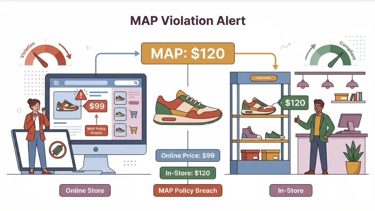
Imagine you’re a sneaker brand. You set a MAP of $120 for your latest model. If a retailer lists it for $99 on their website, that’s a MAP violation—even if they sell it for $120 in-store. Monitoring for these violations means regularly checking retailer sites, marketplaces, and ads to make sure everyone’s playing by the rules.
 MAP monitoring isn’t just about playing price police. It’s about protecting your brand’s perceived value, ensuring a level playing field for all your retail partners, and building trust with customers who expect fairness and consistency—no matter where they shop.
Why Minimum Advertised Price Monitoring Matters for Brands
So, why do brands and distributors invest so much effort in MAP monitoring? Here are the big reasons:
- Protecting Brand Value: Consistent pricing signals quality and stability. MAP violations can make your brand look cheap or out of control.
- Avoiding Price Wars: When one retailer drops their advertised price, others often follow, leading to a race to the bottom that hurts everyone’s margins.
- Supporting Retailer Margins: MAP helps ensure all partners can compete fairly, which strengthens your distribution network.
- Ensuring Customer Trust: Shoppers notice when prices are wildly inconsistent. MAP monitoring helps deliver a reliable, trustworthy experience.
Here’s a quick table of MAP monitoring use cases across industries:
| Industry | MAP Monitoring Use Case | ROI-Focused Benefit |
|---|---|---|
| Luxury Goods | Preventing discounting on new lines | Preserves exclusivity, higher margins |
| Electronics | Controlling online price erosion | Avoids channel conflict, supports dealers |
| Consumer Goods | Monitoring seasonal promotions | Maintains brand equity, reduces churn |
| Sporting Equipment | Enforcing launch pricing | Drives retailer loyalty, prevents leaks |
Real-world studies have shown that unchecked MAP violations can and even lead to retailer retaliation—like dropping your products or demanding steeper discounts. In short: MAP monitoring isn’t just a compliance task; it’s a core part of brand strategy.
The Challenges of Traditional MAP Monitoring Methods
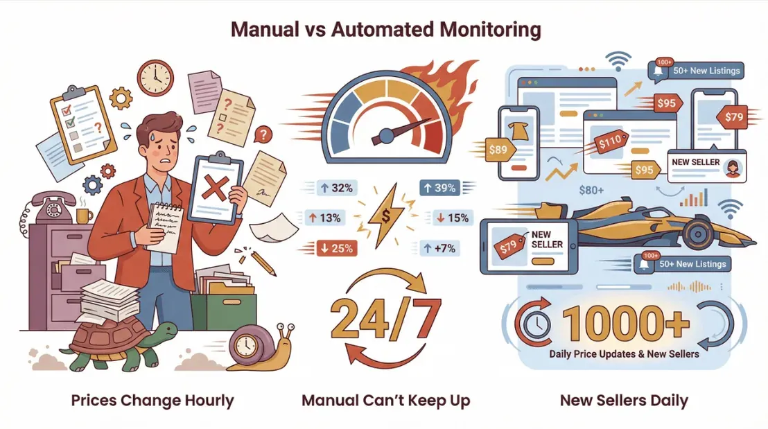
Now for the not-so-fun part. Traditional MAP monitoring often looks like this: someone on your team (usually in sales or ops) spends hours browsing retailer websites, copying prices into a spreadsheet, and manually checking them against your MAP policy. Multiply that by hundreds of SKUs and dozens of channels, and you’ve got a recipe for burnout.
Here’s why manual MAP monitoring just doesn’t cut it anymore:
- Time-Consuming: Manually checking prices for a large catalog can take days—or even weeks—every month.
- Error-Prone: Copy-paste mistakes, missed listings, and outdated data are all too common.
- Impossible to Scale: As your product line and retailer list grow, manual monitoring becomes unsustainable.
- Reactive, Not Proactive: By the time you spot a violation, the damage may already be done.
Let’s put it in perspective:
| Challenge | Manual MAP Monitoring | Impact on Teams |
|---|---|---|
| Time per SKU/channel | 5–10 minutes | 100+ hours/month |
| Error rate | High (missed/incorrect data) | Inaccurate reporting |
| Coverage | Limited (top SKUs only) | Missed violations |
| Response speed | Slow (weekly/monthly checks) | Delayed enforcement |
By 2026, prices on the larger marketplaces shift in minutes rather than hours, and new third-party sellers can appear and disappear over a weekend — manual MAP monitoring at this point is closer to bringing a notepad to a Formula 1 race than to a real enforcement workflow.
Thunderbit: Simplifying MAP Monitoring with AI Web Scraper
Here’s where comes in. As someone who’s spent years in SaaS and automation, I wanted to build a tool that makes MAP monitoring not just possible, but painless—even for teams without technical backgrounds.
Thunderbit is an AI-powered web scraper Chrome Extension (100,000+ users on the Chrome Web Store, last updated May 2026) that automates the process of extracting pricing data from ecommerce sites (think Amazon, Shopify, Walmart, and more). With just a couple of clicks, you can pull advertised prices for all your SKUs, compare them to your MAP policy, and instantly flag violations—no more endless browsing or copy-pasting.
How does it work? Thunderbit’s AI reads the product pages, identifies key fields (like product name, price, seller, and URL), and structures the data for easy export. You can then compare this data to your MAP list and generate reports for your sales or compliance team.
Key Features for MAP Monitoring
Thunderbit is packed with features designed to make MAP monitoring efficient and accurate:
- AI Suggest Fields: Just describe what you want to scrape (“Monitor advertised prices for SKU123”), and Thunderbit’s AI recommends the best fields to extract.
- 2-Click Scraping: Select your target page, click “AI Suggest Fields,” then “Scrape”—that’s it.
- Subpage Scraping: Need more details? Thunderbit can automatically visit each product’s detail page and enrich your dataset with additional info (like seller ratings or promotions).
- Scheduled Scraping: Set up recurring scrapes to monitor prices daily, weekly, or on your own schedule—perfect for ongoing MAP enforcement.
- Instant Data Export: Export your results directly to Excel, Google Sheets, Airtable, or Notion for further analysis or reporting.
These features mean less manual work, fewer errors, and faster detection of MAP violations—so you can focus on protecting your brand, not wrangling spreadsheets.
Step-by-Step Guide: Using Thunderbit for Minimum Advertised Price Monitoring
Let’s walk through how a sales or operations team can use Thunderbit for MAP monitoring—no coding required.
Step 1: Define Your Scraping Intent
Open the and describe your goal in plain English. For example: “Monitor advertised prices for all SKUs in the Spring Collection on Amazon.”
Step 2: Use AI to Recommend Fields
Click “AI Suggest Fields.” Thunderbit’s AI scans the page and suggests relevant columns—typically product name, advertised price, seller, and product URL. You can add or adjust fields as needed (for example, include “promotion details” or “stock status” if relevant).
Step 3: Select Target Webpages
Navigate to the product listing or search results page on your chosen retailer (e.g., Amazon, Shopify store, Walmart). Thunderbit works on almost any ecommerce site, and you can even bulk scrape from a list of URLs if you have a catalog.
Step 4: Run the Scraper and Export Data
Click “Scrape.” Thunderbit extracts the data and presents it in a structured table. Review the results, then export them directly to Excel, Google Sheets, or your preferred platform.
Step 5: Compare to MAP Values and Flag Violations
Import your MAP policy (a simple spreadsheet with SKU and MAP price) and use a formula or filter to flag any listings where the advertised price is below your MAP threshold. Thunderbit’s structured export makes this comparison a breeze.
Pro Tip: Use Thunderbit’s scheduled scraping feature to automate this process—set it to run daily or weekly, and get notified of violations as soon as they happen.
Example Workflow Diagram
- Open Thunderbit → 2. Describe intent → 3. AI suggests fields → 4. Select retailer page → 5. Click Scrape → 6. Export data → 7. Compare to MAP → 8. Flag/report violations
Tips for Accurate and Efficient MAP Monitoring
- Choose the Right Fields: Always include product name, price, seller, and URL for easy cross-referencing.
- Schedule Regular Scrapes: The more frequently you check, the faster you can respond to violations.
- Leverage Subpage Scraping: For products with multiple sellers or variants, use subpage scraping to capture all advertised prices.
- Organize Your Data: Use clear file names and timestamps, and keep your MAP policy list up to date for accurate comparisons.
- Automate Alerts: Set up notifications or dashboards to flag violations in real time.
For more tips, check out the and our .
Comparing MAP Monitoring Solutions: Manual vs. Automated Tools
Let’s put the main approaches side by side:
| Criteria | Manual Monitoring | Traditional Automated Tools | Thunderbit (AI-Powered) |
|---|---|---|---|
| Setup Time | High | Medium | Low (2-click setup) |
| Scalability | Poor | Good | Excellent (bulk, scheduled) |
| Accuracy | Variable (human error) | Good | High (AI-structured data) |
| Cost | High (labor) | Medium–High (licenses) | Low (starts free, pay as you grow) |
| Maintenance | Ongoing (tedious) | Moderate (template upkeep) | Minimal (AI adapts to changes) |
| Data Export | Manual | Varies | Instant (Excel, Sheets, etc.) |
Thunderbit stands out for its ease of use, flexibility, and ability to adapt to changing website layouts—no coding or template maintenance required.
Making MAP Monitoring Part of Your Long-Term Brand Strategy
Efficient MAP monitoring isn’t a one-and-done project—it’s an ongoing process that protects your brand and keeps you competitive. By integrating MAP monitoring into your regular sales and operations workflows, you can:
- Stay Proactive: Scheduled scrapes and automated alerts mean you catch violations early, not after the fact.
- Support Retailer Relationships: Quick, accurate enforcement builds trust with your partners.
- Adapt to Market Changes: As new channels or products launch, Thunderbit’s AI makes it easy to expand your monitoring without extra setup.
For brands serious about long-term growth, MAP monitoring should be as routine as inventory checks or campaign reporting. And with tools like Thunderbit, it’s finally practical to do at scale.
Conclusion & Key Takeaways
Minimum advertised price monitoring is more than a compliance checkbox—it’s a strategic lever for brand protection, retailer fairness, and long-term growth. Manual methods just can’t keep up with today’s fast-paced ecommerce world, but AI-powered automation makes MAP monitoring efficient, accurate, and scalable.
Thunderbit’s streamlines the entire process: describe your intent, let AI suggest the fields, scrape with two clicks, and export your data for instant analysis. Scheduled scrapes and subpage extraction mean you’re always one step ahead of violations.
If you’re still wrangling spreadsheets or relying on outdated tools, now’s the time to upgrade your MAP monitoring approach. Try Thunderbit’s free tier, set up your first scrape, and see how much time (and brand value) you can save.
For more guides and tips, check out the or subscribe to our . Happy monitoring—and may your prices stay right where you want them.
FAQs
1. What is minimum advertised price (MAP) monitoring?
MAP monitoring is the process of tracking and enforcing the lowest price at which retailers can publicly advertise your products. It helps brands maintain consistent pricing, protect brand value, and prevent price wars.
2. How does Thunderbit help with MAP monitoring?
Thunderbit uses AI to extract advertised prices from ecommerce sites, structure the data, and make it easy to compare against your MAP policy. Features like 2-click scraping, subpage extraction, and scheduled scrapes automate the entire process.
3. Can Thunderbit monitor prices across multiple retailers and channels?
Yes. Thunderbit works on most ecommerce platforms (Amazon, Shopify, Walmart, etc.) and can bulk scrape from lists of URLs, making it easy to cover all your sales channels.
4. How often should I run MAP monitoring scrapes?
For best results, schedule scrapes daily or weekly. Frequent monitoring helps you catch violations quickly and respond before they impact your brand or retailer relationships.
5. Is Thunderbit suitable for non-technical users?
Absolutely. Thunderbit is designed for business users—no coding required. Just describe your goal, let the AI suggest fields, and click “Scrape.” Data export is instant and free.
Ready to take your MAP monitoring to the next level? and start automating your price checks today.